The Basics of Land Surveying


land surveying

What is Land Surveying?

Land Surveying dates back to ancient history. Surveying is used for multiple projects.  A survey is done to establish a specific location of a parcel of land along with its exact acreage.  It is used to ascertain boundaries for defining an area of ownership and tax liability.  It is also used to identify a piece of property by a written legal description or to provide a review of the accuracy of an existing description. Data from land surveying is of the utmost importance with regard to buying and selling land, and is also used to insure a clean and marketable title.

Other types of Land Surveying

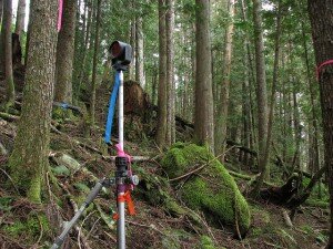
There are many different kinds of surveys that can be performed. Boundary surveying is typically done for undeveloped land. This type of land surveying measures the actual physical extent of the property in question. Most surveys progress through the basic procedures regardless of the type being done. Any pertinent deeds, contracts, maps or other documents that contain a description of the property’s boundaries are located, studied and interpreted. A determination is made of what the actual property description is deemed to be, along with the locations of any physical evidence of the boundaries. This can be in the form of both natural and man-made monuments or markers that exist in the field. The property is then measured to establish the boundaries, not only using the appropriate existing monuments but with the creation and referencing of new markers where necessary. Measurements are accomplished using a total station and other land surveying tools. A total station measures both vertical and horizontal angles, as used in triangulation networks. After these steps are accomplished, the property description and plat are prepared.

Results of land surveying

Interpreting the results of a land survey is not as difficult as it may first seem. For instance, a property plat will usually contain a directional orientation which is typically indicated with an arrow pointing north. It will contain the bearing and distance of each boundary line, the property lines of other properties shown on the plat, and the names of adjacent property owners listed in the areas of their property. Corner monuments, along with the names of any natural monuments (such as “Smith’s Creek”, for example) or a brief description of any unnamed natural monuments (such as the "30-inch pine tree”) are on the plat. There is also a title block containing the property’s location and name of owner, the surveyor’s name, the date the survey was performed, the scale of the plat and any other relevant data.

If you need the services of a surveyor for your land surveying needs, ALWAYS be sure that you’re hiring an experienced, certified, and highly competent professional surveyor. You can find out if the surveyor is licensed by visiting the Board of Licensure's website.

Call Phenix City Land Surveying today at  (334) 408-4311  or fill out a contact form request for more information concerning your land surveying needs.

"Only Transact with a licensed land surveyor for your land surveying needs"

Estimate The Costs Of Flood Damage To Your Home

Why you need a flood survey before building a home?

The tool below allows you to calculate the costs of flooding. Select a home size that approximates yours and then slide the blue button up or down for the expected depth of flooding.

What can a flood survey do for you?

A flood survey can be done by your local land surveyor. This will help you in making important decisions such as buying a property and building your home. Through a flood survey, you get to save thousands of dollars worth of property. Also, you get to protect your family and achieve that peace of mind that everything you've worked hard for is safe. 


flood survey


Call Phenix City Land Surveying TODAY for a free flood risk assessment of your home. We will review the flood maps in your area and advise whether we recommend a flood survey. CALL US TODAY at  (334) 408-4311 or fill out a contact form request. Our flood survey report will give You Peace of Mind.

How To Find Your Home On FEMA’s Flood Insurance Rate Maps

What is are FEMA flood maps?

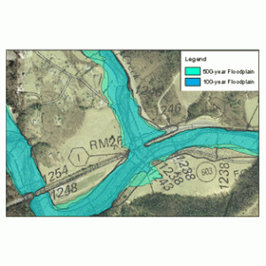
flood mapsFEMA's Flood Insurance Rate Maps (FIRMs) or just Flood Maps are provided after a flood risk assessment has been completed or updated for a community.  This study is known as a Flood Insurance Study.  The FIRM gives you the Base Flood Elevations (BFEs) and insurance risk zones in addition to floodplain boundaries.  The FIRM may also show a delineation of the regulatory floodway. 

Once the "insurance risk zone"  (commonly referred to as the flood zone) is determined, actuarial rates, based on these risk zones, are then applied for newly constructed, substantially approved, and substantially damaged buildings.  FEMA uses these rates to determine the insurance rate you will pay for flood insurance

FEMA's Digital Flood Maps

FEMA discontinued the production and distribution of paper flood maps in 2009 as part of its Digital Vision Initiative. This affected all the Flood Maps, boundary information, and study reports. However, clients can still view the products for free through their website or buy them in digital format.

To view these flood maps online, go to FEMA's Map Service Center and key in your address (hi-lited area shown here) search for your home.  This will prompt you to then select the map that covers your area.  The Flood Maps are somewhat cumbersome to use online. It is best to go through the tutorial on the bottom right of the address search page for an easier and more effective use of the GIS map.

Montgomery Flood Maps by FEMA

If you are located in the City of Montgomery, you might also want to check the Phenix City Interactive GIS maps for more information and a little easier interface. Check the FEMA Flood Insurance Rate Map box on the left to view the flood zones on this map.

Call Phenix City Land Surveying at  (334) 408-4311 or  contact us if you need help with this process or if you discover you are near a flood zone and need an elevation survey completed.  We are here to help you minimize your flooding risk.